Examine, with the aid of a labelled diagram or diagrams, the processes that have led to the formation of any one Irish landform of your choice.
The landform I have chosen to examine is a waterfall - Example Powerscourt, Co. Wicklow.
A waterfall is a feature of river erosion. Most waterfalls are found in the upper course. They generally develop where a river meets a band of less resistant rock after flowing over more resistant rock. Differential erosion occurs. The less resistant rock is eroded by abrasion (river’s load hits off the banks and bed of the river eroding it) and by hydraulic action (the force of the water itself erodes). The hard rock is under cut. With no underlying support it will eventually collapse. The rock at the base of the waterfall is eroded by the swirling action of the fallen rock, creating a plunge pool. Hydraulic action is an effective process here due to the falling water, which has less friction and more velocity. These processes of undercutting and collapse are repeated causing headward erosion. The waterfall retreats upstream. A steep-sided gorge is created.

Explain how the study of plate tectonics has helped us to understand the global distribution of volcanoes.
Volcanoes mostly occur at plate margins. They can also occur at hot spots and in rift valleys. The most active volcanic zone is the Pacific Ring of Fire around the Pacific plate. Here plates are colliding or separating. At active points on these plates volcanic mountains are formed, e.g. Nazca Plate and South American Plate, where plates separate, e.g. Pacific and Nazca Plate and in rift valleys, e.g. African Plate, Kenya. The most active area on the globe is the western rim of the Pacific Plate - stretching from Russia to New Zealand.
Several findings relating to earthquakes and volcanic activity can be explained by plate tectonics. If you follow news stories of earthquakes, you may begin to wonder why such places as California or Japan have so many earthquakes, whereas the north eastern United States or Western Europe have so few. The fact is that earthquakes occur along belts and the vast majority of these belts lie on the boundaries of the earth’s tectonic plates. The same is true of volcanoes and locations known for earthquakes, such as the Philippines, have many volcanoes.
The Hawaiian Islands are located near the centre of the Pacific Plate. These islands of Hawaii experience plate movement, helping to form the volcanoes that created those islands. At the south of the island group, many volcanoes are still active, while those to the north are mainly dormant. The reason for this is that the Pacific Plate is moving north over a stationary lava source (mantle plume) below Hawaii. The south islands remain above it, while the northern islands have moved away.

The Oceanic crust tends to be youngest at the centre of ocean basins and along mid-ocean ridges, or along submarine ridges where new seafloor is created. There is much volcanic activity here as massive fissure eruptions frequently occur. Crusts of oceanic and continental type differ by their thickness and by
With reference to the Irish landscape, examine the processes which have influenced the development of any landform in a karst region.
The feature I have chosen to examine is limestone pavement.
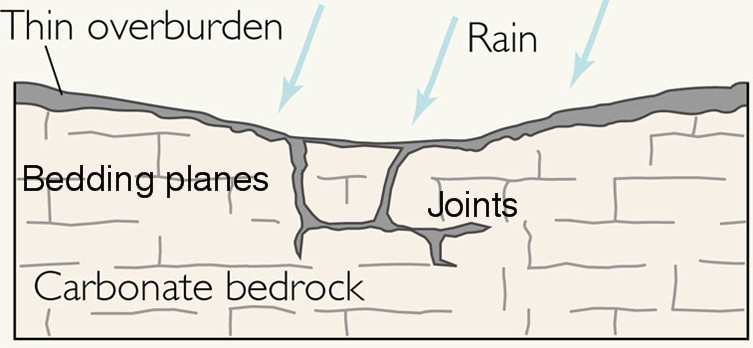 Carboniferous limestone is a sedimentary rock. It is a stratified rock composed of calcium-carbonate (Ca Co3). It was formed in warm tropical waters where marine creature remains accumulated, compacted and cemented. Carboniferous limestone can produce a distinctive landscape called Karst. An example of a Karst landscape is the Burren, Co. Clare. This landscape was created due to the chemical weathering of carboniferous limestone. Carbonation is the most significant process involved in the shaping of a limestone landscape. Carbon dioxide from the atmosphere or soil mixes with rainwater to form a weak carbonic acid (H2O + CO2 = H2CO3). This acid alters the insoluble calcium carbonate of limestone to soluble calcium bicarbonate, which is then removed by solution (H2CO3+CACO3=CA(HCO3)2. This process creates distinct features like limestone pavements. Joints or fissures in the limestone become enlarged by carbonation. They are widened and deepened to form grikes. The flat topped residual blocks separating the grikes are called clints.
 Examine, with reference to an example you have studies, the formation of one rock-type and how it produces a distinctive landscape.
In my answer I will discuss carboniferous limestone of the Burren Co. Clare. This is a sedimentary rock. It is a stratified rock composed of calcium-carbonate (Ca Co3). It was formed in warm tropical waters where marine creature remains accumulated, compacted and cemented. Carboniferous limestone can produce a distinctive landscape called karst. An example of a karst landscape is the Burren, Co. Clare. This landscape was firstly exposed at the end of the last glaciations when the stone appeared from under the glaciers as they melted. The surface of the Burren was wiped clean by the mechanical erosion of the ice sheets as they moved to the west and north.
The area as we know it today has been created due to the chemical erosion of carboniferous limestone. Carbonation is the most significant process involved in the shaping of a limestone landscape. Carbon dioxide from the atmosphere or soil mixes with rainwater to form a weak carbonic acid (H2O + CO2 = H2CO3). This acid alters the insoluble calcium carbonate of limestone to soluble calcium bicarbonate, which is then removed by solution (H2CO3+CACO3 = CA (HCO3)2. This process creates distinct features like limestone pavements. Joints or fissures in the limestone become enlarged by carbonation. They are widened and deepened to form grikes. The flat topped residual blocks separating the grikes are called clints. Solution holes called karrens may form on the pavement. Other distinct features found in this landscape are swallow holes, dolines, caves, stalactites and stalagmites.Examine, with reference to actual examples, the measurement and effects of earthquakes.
How destructive an earthquake is depends on a number of factors including the time of year and the time of day that it occurs, the population density, the economic wealth of the country, the type of construction of the buildings, the geology of the area and the magnitude and duration of the earthquake.The most destructive earthquakes occur in areas with high population densities. Ground vibrations cause more damage and loss of life than any other earthquake hazard, particularly if the ground is unconsolidated (silt, sediment) and buildings poorly constructed. Liquefaction can occur, destroying structures.
The Pakistan earthquake, in October 2005 had hazardous effect. The Pakistan earthquake measured 7.6 on the Richter scale and killed 79,000 people. Most died when poorly constructed buildings collapsed. Remote and isolated communities made it difficult to access injured people. There were limited resources to deal with the disaster e.g. home-made stretchers, aid supplies had to be carried by mule, no electricity or telephone lines. The Los Angeles earthquake measured 6.7 on the Richter scale and lasted 40 seconds. Just over 60 people were killed. The number of deaths would have been higher had the earth quake not occurred early in the morning of a public holiday and also if the buildings had not been reinforced with steel. Most of the deaths and destruction occurred in older, poorly constructed buildings. Emergency measures had been well planned and rescue operations went well. Rescuers had up-to-date equipment, e.g. fibre-optic cameras.
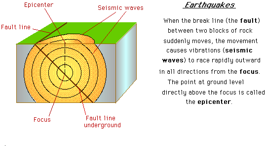 Seismologists detect seismic activity using seismometers, instruments for detecting seismic waves, and seismographs which record data about waves. Tilt meters are also used in the prediction of earthquake activity. Here, changes in the shape of the earth’s crust can be measured prior to a tectonic event; however, earthquakes occur at such a fast rate it is often too late to take remedial action against the earthquakes. In some instances animal activity has been noted to be abnormal prior to an imminent quake. This occurred in Thailand prior to the tsunami in 2004. Animals left the coastal villages and headed for the higher land behind the villages.
Examine the impact of folding and faulting on the landscape. In your answer refer to one landform in each case.
 Forces of compression fold rocks into landforms called mountains. The intensity of folding determines the shape of the mountain. Forces if compression or tension can also cause fractures or faults in the earth’s crust. Faults are lines of weakness.
Secondly, I will refer to the faulting of the African Rift Valley. It is approximately 6,000km in length and runs from Syria to Mozambique. It has forms due to diverging plates. This faulting activity has weakened the earth’s crust along these margins. The area is therefore prone to volcanic and seismic activity.
No comments:
Post a Comment